
After a crisp start to October, residents across Newfoundland & Labrador should prepare for a noticeable uptick in temperatures over the coming days. Forecasters are calling for daytime highs in many regions to climb well above the seasonal norm, bringing a taste of late-summer warmth before a more autumnal cooldown later in the week.
What’s the Forecast?
-
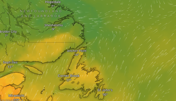
In St. John’s, temperatures are expected to hit near 20 °C by Tuesday and Wednesday, nearing a long-standing record of 21 °C set in 1976.
-
Across the island more broadly, highs in the mid to upper teens (Celsius) are predicted through midweek, with a gradual shift toward cooler, wetter conditions by Thursday.
-
Nights will remain mild, with lows in many areas hovering in the low double digits (°C) through midweek, rather than plunging into the single digits as might be typical this time of year.
This pattern contrasts with what is more typical for early October — namely cooler daytime highs and brisk, chillier nights.
Why the Warm Spell?
Several factors are combining to push temperatures above normal:
-
A milder air mass moving in
A southerly to southwesterly flow is ushering in warmer air from lower latitudes, moderating daytime highs and slowing nighttime cooling. -
Reduced influence of onshore sea breezes
Coastal areas normally benefit from cooler sea breezes, but during this warm-air push, parts of the island less affected by strong maritime winds will heat up the most. -
Ocean temperature anomalies
The North Atlantic has been running warmer than average in recent seasons, which can help moderate air temperatures along Newfoundland’s coasts and reduce heat loss overnight. -
Longer-term warming trends
The backdrop of climate change is nudging base temperatures upward. Over recent decades, Newfoundland has seen average annual temperatures increase by roughly 0.8–1.5 °C above historical norms, altering the seasonal baseline. -
Atmospheric dynamics
Broadscale circulation patterns, such as ridging or weaker cold fronts in the region, can favor more persistent warmth. While Newfoundland lies near a cool patch in the North Atlantic known as the “warming hole,” shifting wind patterns may lessen its cooling influence in the short term.
What to Watch For & When to Expect a Change
-
The warmest stretch looks to span Tuesday to Wednesday, with cloud breaks helping maximize daytime warming.
-
By Thursday, the trend will begin reversing: clouds increase, rain is likely, and temperatures will ease back downward.
-
Though this warm spell may feel late for many, it’s not unprecedented. Still, it serves as a reminder of the changing climate backdrop — warmer swings are becoming more frequent.
Tips for Residents
-
Take advantage of the milder conditions: ideal for outdoor chores, walks, or catching up on yard work.
-
But be mindful of UV exposure — even in fall, sunny breaks can yield stronger sun than expected.
-
Watch for shifting weather mid-week: if heading out Thursday onward, layer up and have rain gear ready.
-
This warm spell is temporary; autumn’s chill is likely to reassert itself later in the week.