
Residents of Newfoundland are bracing for the first significant winter storm of the season, expected to hit late tonight and continue through Wednesday. Snow, wind, and rain will affect much of the Island, with Environment and Climate Change Canada issuing multiple warnings.
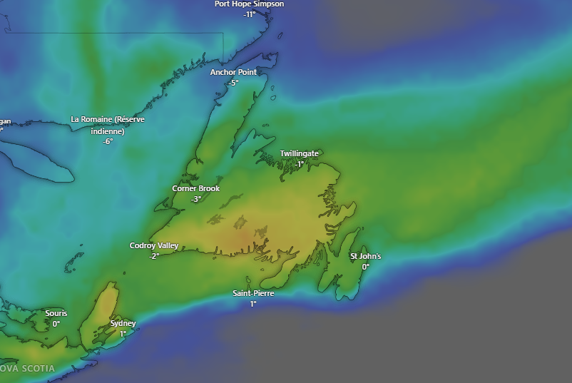
Today, the weather is relatively calm, with a mix of sun and clouds and highs near or below freezing. Wind speeds will ease throughout the day, giving residents a chance to prepare for tomorrow’s snow. Clouds will increase across the Island this afternoon.
The storm will bring heavy snow to northern parts of the Burin and Avalon Peninsulas, including the St. John’s Metro area, where snow may persist longer before transitioning to rain or ice pellets. Accumulations could reach up to 30 cm in some areas, with sharp gradients between heavy snow inland and lighter amounts closer to the coast.
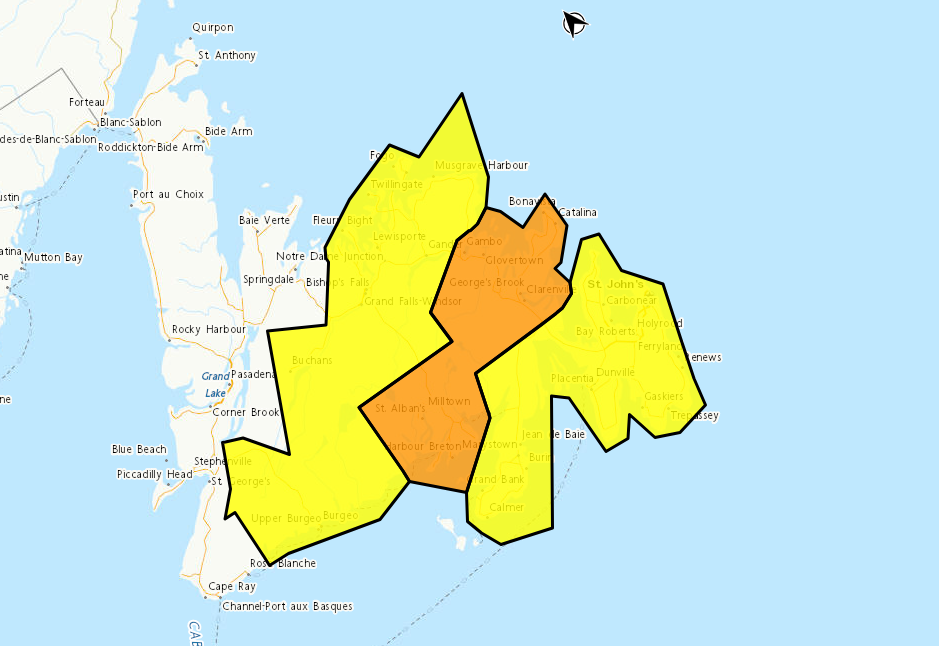
Warnings and Forecast Highlights:
-
Winter Storm Warning (Orange Level) – Connaigre, Bonavista Peninsula, Clarenville, Terra Nova
-
Snowfall: 30–40 cm (locally higher)
-
Winds: Northeasterly gusts 80–100 km/h
-
Timing: Overnight tonight through late Wednesday
-
Travel will be hazardous with heavy, wet snow and reduced visibility.
-
-
Winter Storm Warning (Yellow Level) – Burgeo–Ramea
-
Snowfall: 10–25 cm
-
Winds: Northeasterly gusts up to 100 km/h
-
Timing: Overnight tonight through late Wednesday
-
Inland areas and higher terrain will see the most snow; travel disruptions are expected.
-
-
Snowfall Warning (Yellow Level) – Avalon & Burin Peninsulas
-
Snowfall: 15–30 cm, locally higher
-
Timing: Overnight tonight to late Wednesday
-
Snow may mix with rain near the coast; expect wet, heavy snow and potential utility disruptions.
-
-
Snowfall Warning (Yellow Level) – Interior & Northeastern Newfoundland
-
Snowfall: 10–20 cm
-
Timing: Overnight tonight through late Wednesday
-
Reduced visibility and challenging travel conditions expected.
-
-
Wind Warning (Yellow Level) – Burin Peninsula
-
Gusts: Up to 100 km/h
-
Timing: Around noon Wednesday through evening
-
Potential for local damage, service disruptions, and utility outages.
-
Residents are advised to avoid non-essential travel, exercise caution when shoveling, and stay updated on forecast changes as the system moves through the region.
For continuous updates, NLWX recommends checking local road cams and provincial forecasts.